Object number1976.77
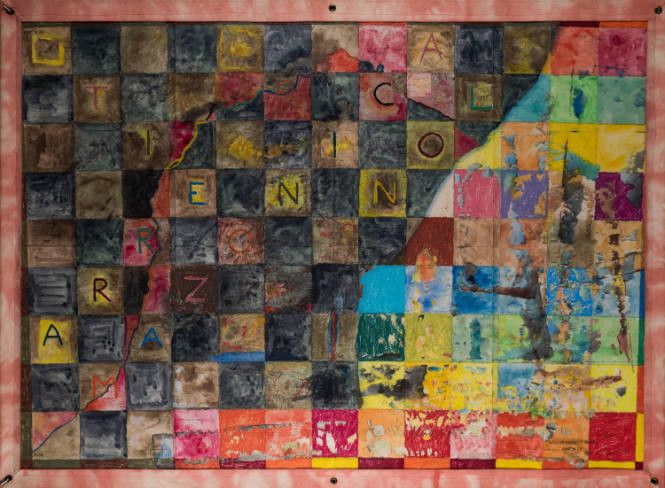
Cuando despierte...
Date1975
Artist
Rafael Ferrer
(Puerto Rican, b. 1933)
CulturePuerto Rican
MediumOil crayon and watercolor on a United States Air Force Operational Navigation Chart, sewed within a plastic and watercolored textile bordered enclosure
DimensionsSheet: 40 1/4 x 56 in. (102.2 x 142.2 cm)
Composition: 44 1/8 x 60 in. (112.1 x 152.4 cm)
Composition: 44 1/8 x 60 in. (112.1 x 152.4 cm)
Credit LinePurchase, Barbara Doyle Duncan, class of 1943, Fund for Contemporary Latin American Drawings
On View
Not on viewPeriod20th c
Classification(s)
SignedOn recto within image, signed lower right in pencil: R. Ferrer
InscribedOn recto within image, by artist, lower right in pencil: cuando despierte... / Brasil ["i" is dotted by a heart] / 1975; within squares in various arrangements and colors: ARRE / AMAZONICA / TIERRA / FIN; printed within the map are various locations, numbers, keys and words such as: SAO FRANCISCO RIVER / ONC N-28
ProvenancePurchased from Nancy Hoffman GalleryVassar Exhibitions
Label TextRafael Ferrer, a Puerto Rican artist trained in Paris, sought to capture in his work a disavowal of the tropical Caribbean as a tourist’s paradise. His artwork in the 1970s addresses the political, social, and economic plight of his native Puerto Rico, the wider Caribbean, and Latin America under U.S. domination. Ferrer’s influential map series includes over one hundred works painted on print maps and navigational charts he acquired in Philadelphia. This remarkable watercolor, When It Awakens..., is one of the earliest and most important works from that series. Ferrer painted over a US Air Force operational chart showing the coast of Brazil and part of its Amazonian region around the São Francisco River, superimposing a colorful checkerboard gird of letters forming the words arre, Amazonia, and no. Through layers of lines, colors, and words, the artist repurposes the map into a visual manifesto, in essence denying its power to continue to represent a violent history of colonization and exploitation.
DescriptionAn aerial navigation map with elevation of the São Francisco river region divided into a colorful, almost quilt-like grid. Letters are arranged in diagonals to form various Spanish words and the printed material of the map is still visible under the applied colors.
Object information is a work in progress and may be updated as new research findings emerge.
To help improve this record, please email
loebcollections@vassar.edu